
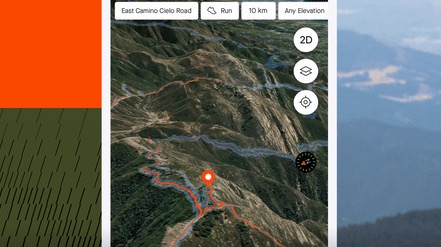
Strava has introduced 3D maps, which will be available on the mobile app (both iOS and Android) for subscribers to the platform. Combined with Strava’s recent ‘Points of Interest’ feature announcement, athletes will now be able to visualise topography more easily to establish their location and plan their routes and breaks.
The company notes that.. ‘this update will allow Strava athletes to confidently plan adventures and hit trails with ease, visualise the difficulty of different journeys, and make informed decisions on the go.’ With the maps showing topography and elevation to scale, athletes can seek out challenging inclines or a more relaxed route home. Though seen as being useful for all athletes, performance athletes can seek out elevation challenges and tailor outdoor training programmes to suit their goals (e.g. climb training and VO2 Max efforts).
The company adds that this latest product development also signifies the next step in making Strava an ideal workout partner for trail sports athletes, who can hit unfamiliar trails knowing what they’re in for and how they get home. For subscribers, the feature can be found on the mobile app by going to the Routes or Record tab, or by clicking into any activity map.